Initiatives and Strategies

NDOT has implemented various TSMO strategies throughout Nevada. All of these strategies and initiatives aim to maximize the safety, efficiency of both existing and planned transportation infrastructure. Some of the initiatives and strategies that NDOT has adopted are discussed below.

Nevada Traffic Incident Management Coalition strategy description
Incident management Software in Southern Nevada Traffic Management Center description
Active Traffic Management strategy description
Connected an Autonomous Vehicles strategy description
Strategic Traffic Management Sites strategy description
high Occupancy Vehicle (HOV) Lanes strategy description
Work zones strategy description
integrated Safety Technology Corridor project description
TSMO Workforce Development Plan description
Smart Mobility Planning strategy description
Advanced Traveler Information System strategy description

Nevada Traffic Incident Management Coalition

TIM Coalition logo
For more information on Nevada TIM, please visit: http://nvtim.com

Traffic Incident Management (TIM) is a planned and coordinated process by various public agencies and private sector partners to detect, respond to, and remove traffic incidents to restore traffic capacity as safely and quickly as possible.

Nevada TIM Coalition provides a forum for discussions, incident debriefings, state and regional policies and procedures in order to enhance coordinated response time for safe, quick removal of incidents from the roadway. TIM meetings are open to TIM Coalition members.

Connected and Autonomous Vehicles

Connected Vehicles (CV’s) share transportation information with other vehicles (V2V), the infrastructure (V2I), or with any entity in the transportation system such as pedestrians, vehicles, transportation infrastructure, and wireless networks (V2X).

Autonomous Vehicles (AV’s) use information from internal sensors to detect and navigate within the roadway environment. These vehicles operate in isolation from other vehicles. There are different levels of AV’s depending on the level of automation:

Levels of Automation

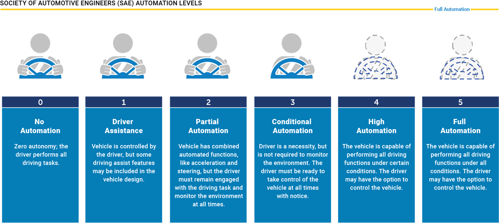
A Connected and Autonomous Vehicle (CAV) has both in-vehicle sensors and connectivity with other vehicles and roadway infrastructure. CAVs have the potential to provide a lot of benefits such as:

  • Reducing travel times
  • Improving the safety of the transportation system
  • Enabling new models of vehicle ownership
  • Enabling new business models
  • Changing the need for future long-term capacity expansion projects
  • Reducing the need for parking

While CAVs offer many potential benefits, there are still many challenges that are associated with the adoption of CAVs:

Deployment IssuesPolicy IssuesOperational Issues
SecurityNeed for National StandardsImpact on urban and rural mobility
Extent and availability of CommunicationsNew Liability and Insurance RegulationsRole of the private sector
Public AcceptanceNeed for process for approving AVs for public useImpact on today’s workforce
Interoperability Expectation of the public sector
Need for real-world testing Need for AVs to co-exist with driver operated vehicles


Work Zones

Work zone areas present several hazards for motorists. Examples of such hazards include traffic congestion due to reduced lanes, uneven roadways or shoulders, and construction equipment on or near the roadway. TSMO strategies can be used to mitigate the risk posed by some of these hazards. In 2019, NDOT published the “Work Zone Safety and Mobility Implementation Guide” whose purpose is to establish the fundamental principles, roles, responsibilities, and procedures for systematically addressing the safety and mobility impacts of work zones and developing strategies to help manage these impacts.

The Guide establishes state-wide processes and procedures as well as project-level procedures to address the impacts of work zones. A key principle advanced by the Guide is that work zone mitigations should be customized to the specific needs of each work zone.

The Guide is updated every two years. A copy of the 2019 Guide can be found here.

Some examples of how NDOT has incorporated TSMO into work zone areas include:

NDOT Smart Work Zone: NDOT has implemented multiple Smart Work Zone projects within the state of Nevada. An example is a deployment on SR160 to address traffic disruptions caused by a widening project. As part of the project, NDOT deployed a queue warning and dynamic travel time system to provide the road users with critical construction information in a timely manner. The components include:

  • Monitoring of traveling speeds of traffic
  • Speed thresholds reached, pre-programmed messages update
  • The solar battery charging system
  • Portable and easy to setup
  • Ability to view live traffic data
  • Waze connected
  • Self-contained operating system

RTC SNV Work Zone Safety: The Regional Transportation Commission (RTC) of Southern Nevada (SNV) was challenged with obtaining accurate information about construction zones in its jurisdiction. The construction zones are managed by different agencies and are constantly shifting based on project needs. Consequently, the impact on traffic is difficult to gauge accurately. Nexar’s City Stream platform uses dashcams in private vehicles, taxis, and transportation network vehicles, such as Uber, to identify temporary traffic control devices. The footage allows Nexar to then analyze the effect on traffic location, date, time, and the number of traffic lanes affected, and it provides a video frame image of the detected activity. In addition, the system can report near-miss collisions or harsh braking situations—safety issues that previously were never recorded or monitored for causation trends and secondary effects (Roads and Bridges, 2020). RTC also uses iCone traffic control beacons that are installed on cones, drums, and other traffic control devices. Both the Nexar and iCone data are provided to the public through Waze. The provision of accurate roadway information from these platforms allows the public to make more informed travel decisions.

Smart Mobility Planning

NDOT’s Smart Mobility Plan is a short-medium term plan for the statewide deployment of new technologies in the transportation sector. The plan defines NDOT’s goals to improve the safety and efficiency of Nevada’s transportation system through the use of technology. The plan will help to prepare NDOT’s communication systems, data management systems, and related ITS infrastructure to fully capture the benefits of innovations in transportation technology.

The plan identifies the following as key strategic components to achieving smart mobility across Nevada:

Smart Mobility ComponentStrategy
FinancialAchieve COTS solution for Smart Mobility, providing consistent vendor selection process and cost-optimized decision-making framework that fits within the Department’s budget
Key Performance Indicators (KPIs)Achieve effective measurement & metrics of COTS solution for Smart Mobility
DataImproved availability of mobility data to support planning, operations, and performance measure activities
DevicesImplement technology solutions and strategies on Nevada roadways and collaborate within NDOT and partnering agencies to provide the department and the traveling public timely, reliable, and accurate information to facilitate safety and operational efficiency
Infrastructure CloudImplement technology solutions and strategies on Nevada roadways and collaborate within NDOT and partnering agencies to provide the department and the traveling public timely, reliable, and accurate information to facilitate safety and operational efficiency
Staffing ResourcesDelivering a robust and sustainable TSMO Program with the appropriate staffing and resources founded by the TSMO knowledge, skills and abilities 
TrainingDelivering a robust and sustainable TSMO Program is dependent on staffing and workforce with appropriate TSMO knowledge and skills
RegulatoryLegislation established for a performance-based highway program funding transportation programs focused on national and local transportation goals and increased accountability and transparency
SafetyImplement solutions on Nevada roadways and collaborate within NDOT and Partnering Agencies to include TSMO strategies such as Traffic Incident Management, Work Zone Management, Special Event Management, and Road Weather Management
CommunicationsImplement technology solutions and strategies on Nevada roadways and collaborate within NDOT and partnering agencies to provide the department and the traveling public timely, reliable, and accurate information to facilitate safety and operational efficiency.
ITS Asset ManagementImplement technology solutions and strategies to effectively manage ITS infrastructure thereby facilitating performance-based planning, cost-estimating, reporting and accountability activities
SecurityImplement technology solutions and strategies on Nevada roadways and collaborate within NDOT and partnering agencies to provide a secure solution for their information and service delivery requirements.

Incident Management Software In Southern Nevada Traffic Management Center

Background

The Southern Nevada Traffic Management Center (TMC) is the hub of traffic communications for the Southern Nevada region. The TMC houses four distinct agencies that cooperatively oversee freeway and arterial operations. These agencies include the Nevada Department of Transportation (NDOT), which operates the Freeway Service Patrol (FSP) and Las Vegas ROADS, (the freeway maintenance and FSP dispatch); the Nevada Highway Patrol (NHP); the Nevada Department of Public Safety (DPS-NHP dispatch); and FAST (a division of the Regional Transportation Commission of Southern Nevada), which operates Southern Nevada traffic signals and ITS devices.

Although housed in the same facility and the same operations theater, there was never a collective platform on which all agencies shared real-time incident data. As a result, valuable information was often kept from traffic managers, impacting their ability to respond to changing scene safety immediately.

Arcadis InSIGHT ATMS Platform

NDOT has partnered with Arcadis for the deployment of the inSIGHT Advanced Transportation Management System (ATMS). As part of Arcadis’ scope of work for NDOT, it will help modernize the statewide freeway management software by replacing the legacy ATMS application with the inSIGHT ATMS software solution. Designed to enhance safety and reduce congestion on Nevada freeways, inSIGHT ATMS provides real-time situational awareness through video camera integration, traffic sensors, weather sensors, and other interfaces. The system automates tasks, such as modifying speed limits, coordinating with crowdsourced real-time navigation applications such as Waze, and posting messages on roadside signs. This automation improves response times, accelerates incident clearance, and minimizes the environmental impact of traffic congestion.

Arcadis is also delivering its real-time Travel-IQ Advanced Traveler Information Systems (ATIS) to upgrade the Nevada 511 website, mobile app, Event Reporting System (ERS), and Interactive Voice Response (IVR) systems to provide real-time, personalized, and accessible travel information to the public. The user-friendly website and app offer up-to-date details on traffic, road conditions, and live video feeds, enhancing road safety and community engagement.

Strategic Traffic Management Sites

Strategic Traffic Management Sites (STMS) are physical structures built off the side of the travel lanes to elevate police vehicles with their flashing lights, prompting motorists to reduce their speed as shown below.

Photo of a strategic traffic management site on I-15, Las Vegas, nevada
Strategic Traffic Management Site

In key Southern Nevada interstates, the locations, days, and hours with the highest density of traffic incidents were selected. NDOT then built STMS in a strategic upstream location nearest to the identified area. NHP uses these sites to position troopers during key periods when preventive action will be the most beneficial. Finally, RTC coordinates with NHP to update dynamic messaging signs, alerting drivers when they are approaching a preventive activity zone.

STMS have a measurable traffic calming effect, which creates safer roadways. In the pilot program, the overall results showed that 91 percent of speeding drivers slowed down below the 65-mph speed limit while the STMS were active. Further, there was a 17 percent reduction in crashes observed during this time. Since then, NHP troopers have been deployed several times each month (in July 2020, there were 29 preventive activity events at three sites). Comparing historical crash rates, RTC found a 45 percent reduction between the three sites.

Fewer crashes are metric in and of itself, but it is a compounding factor in terms of less lane time blockage, fewer secondary crashes, and improved system efficiency. The use of Connected Vehicle data to measure driver behavior, such as harsh braking, also enables a number of actionable safety insights.

As part of the Integrated Safety Technology Corridor, RTC will identify, deploy, and evaluate additional STMS locations and coverage times. The learnings from this project will provide RTC with valuable feedback to expand coverage beyond the corridor and key information for FHWA and other communities to consider.

Integrated Safety Technology Corridor

US-95 is a major north-south highway that traverses five different states over its 1,574 miles. One of its major junctions lies within Nevada, where it crosses with I-15 in the City of Las Vegas. This section of US-95 is significant as it connects downtown Las Vegas and the Resort Corridor with the growing suburbs; average daily volumes exceed 250,000 vehicles per day with growth rates exceeding five percent per year during the past decade. As such, safety and efficiency are particularly paramount, given the proximity to the Spaghetti Bowl, a major freeway interchange connecting I-15, I-515, US-93, and US-95. Spillover from incidents on US- 95 has major implications for the rest of these thruways and the communities beyond.

Integrate Safety Technology Corridor project location map on US-95, Nevada
ITSC Project Location

The Regional Transportation Commission of Southern Nevada (RTC) will deploy Integrated Corridor Management strategies in a critical corridor along US-95 in the Las Vegas metropolitan area, hereafter referred to as the Integrated Safety Technology Corridor (ISTC). The ISTC will deploy, evaluate, and refine the use of emerging technologies and data analytics. These include the deployment of various sensors and devices, communications networks, analytical tools, and related technologies. It will enhance safety, reduce travel times, improve reliability, air quality, and overall operational efficiencies on this critical freeway section that crosses through the Las Vegas metropolitan area. The technology deployment and evaluation will focus on Active Traffic Management (ATM), Wrong-Way Driver system, Strategic Traffic Management Sites (STMS), and High-Occupancy Vehicle (HOV) Occupancy detection. The proposed project will expand the region’s safety efforts implemented over the past two years and build on established partnerships to expeditiously realize benefits.

Project Plan

This project directly addresses the Advanced Transportation and Congestion Management Technologies Deployment (ATCMTD) initiative’s goals, objectives, and focus areas by developing a model deployment site for a large-scale installation and operation of advanced transportation technologies to improve safety, efficiency, and system performance. The project will benefit passenger and freight movement and address other societal and equity considerations. These include substantial infrastructure investments in a corridor that is located in a socio-economically depressed urban core area. As part of the deployment of new sensors and devices on the corridor, it will be imperative to connect and synthesize these new data sources to a cloud-based platform where the RTC and regional partners can communicate and collaborate effectively. The incorporation of these technologies under this regional platform represents the next step in the evolution of RTC’s traffic management in the area. RTC will rely on NDOT for their expertise in the planning, operational, and construction stages. NHP will use the actionable insights and provide safety enforcement along the corridor. The University of Nevada, Las Vegas (UNLV) will conduct a detailed analysis of the system and technologies at work, providing the Federal Highway Administration (FHWA), U.S. Department of Transportation, and related agencies with valuable operational data and feedback to inform future decision-making and best practices.

Transportation Systems Management and Operations (TSMO)

To further NDOT’s mission, RTC is creating a regional TSMO Program—founded on the NDOT TSMO Program Plan. RTC’s program will provide specific guidelines to implement TSMO and lays the foundations to mainstream policies at the agency level. As part of the first steps, RTC will assess NDOT with respect to the Capability Maturity Framework along with incorporating its partnering agencies. NDOT is encouraged to have all of its divisions working collaboratively and following the recommended steps within this Program Plan to instill TSMO in everyday business practices. All of the proposed project components align with this program. TSMO has proven to be effective at helping departments of transportation across the nation maximize the safety and efficiency of their highway systems.

Benefits

This project seeks to deliver on a number of benefits to the agencies involved, as well as the public at large. The road-infrastructure components address the following categories laid out in the table below and detailed in subsequent sections of the project narrative

ComponentData Used / CollectedWhat is QuantifiedWhat the Public SeesBenefits
Traffic
Management
Speed and volume
data from sensors
Corridor throughputLane management
and variable speed
limits
Reduce crashes,
fatalities and injuries,
Reduce congestion
and improve reliability,
Reduce emissions,
Public access to real
time integrated
information, Cost
savings
Wrong-Way
Driver
Wrong-way driver
events
Variables related to
the event
Driver is
immediately and
aggressively
warned by beacons
Reduce fatalities and
injuries, Cost savings
Strategic
Traffic
Management
Site
Predictive data
fused from sensors
and in-vehicle
devices
Compares current
performance with
near-term
performance and
likelihood of
incidents
Posted messages
and law
enforcement
vehicles at key
locations during
critical times
Reduce crashes,
fatalities and injuries,
Reduce congestion
and improve reliability,
Reduce emissions,
Cost savings
HOV
Occupancy
Vehicle occupancy
data
Vehicle Occupancy
and HOV
performance
Detection not
visible by public
Reduce congestion
and improve reliability,
Reduce emissions,
Optimize multi-modal
performance, Improve
access to alternatives,
Cost savings


Advanced Traveler Information System

An Advanced Traveler Information System (ATIS) is any system that acquires, analyzes, and presents information to assist freeway travelers in moving from a starting location (origin) to their desired destination. Relevant information may include locations of incidents, weather and road conditions, optimal routes, recommended speeds, and lane restrictions.

511 Nevada Travel Info is a free phone and web service that brings together traffic and transportation information into a one-stop resource for commuters and motorists in Nevada. 511 Nevada provides up-to-the-minute traffic conditions and is available by phone and on the internet seven days a week, 365 days a year.

Traffic and travel information offered on the 511 Nevada web site and telephone phone service is managed by a partnership of public agencies led by the Nevada Department of Transportation. Data is provided by traffic monitoring devices on Nevada’s roads such as traffic cameras and travel time sensors.

511 Nevada provides motorist information about accidents, construction, scheduled maintenance, weather, and other conditions on Nevada Interstate and state highways. It offers real-time traffic and travel information seven days a week, 365 days a year. In addition, 511 Nevada broadcasts AMBER alerts and other statewide emergency messages.

511 Nevada greatly benefits motorists and commuters. By using any of the 511 Nevada resources, motorists can make informed decisions about planning trips, possible alternate routes, and departure times. This can improve individual drivers’ trips, helps reduce congestion and improve safety on state highways. 511 Nevada also provides a personalized traveler service (My511NV) to help motorists better navigate Nevada’s highways. This is a free subscription-based service that allows users to customize the traveler information that is important for them and to select specific event information along user-defined routes to be delivered right to a subscribers’ cell phone or e-mail accounts.

Active Traffic Management

The Las Vegas metropolitan area is managed through a network of Intelligent Transportation System (ITS) technologies on the freeways and on the arterials through a central management system. With a need to put greater focus on congestion management on key freeway corridors, NDOT identified the opportunity to introduce its first ATM application in the state in coordination with Project NEON in Las Vegas. The graphic below illustrates the recurring and nonrecurring factors that contribute to congestion in the United States.

Causes of Congestion in the United States. (Source: Congestion Mitigation FHWA)

Recurring congestion accounts for about 45 percent of all congestion in the United States while nonrecurring congestion accounts for 55 percent of all congestion. 
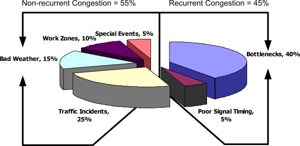
Agencies conduct freeway management and traffic operations through policies, strategies, and actions that enhance mobility and combat recurring congestion in the freeway environment. Strategies to address recurring congestion include roadway widening and bottleneck removal, operational improvements, ramp management and control, and managed lanes. Mitigation techniques for nonrecurring congestion include better management of incidents, work zones, road weather, and planned special events that impact the roadway. All of these strategies look to optimize the use of existing transportation facilities.  ATM techniques target collisions that result from both recurrent and non-recurrent congestion and is a tool that can improve safety and throughput and may be used as an interim strategy to enhance the efficiency of corridors that may ultimately receive major capital investments. ATM technologies and applications have been carefully chosen by NDOT and its partners to combat both recurrent and nonrecurrent congestion that impacts the I-15 and US-95 freeways that serve the Las Vegas metropolitan area for commuters, visitors, long-haul truckers and local traffic

NDOT Active Traffic Management (ATM) project limits map
NDOT ATM Project Limits

ATM encompasses a variety of applications or strategies that range in complexity and functionality and can be used to provide spot improvements to the transportation system as well as corridor-wide benefits. The NDOT ATM system will use input from roadway sensors as well as human operators at the FAST TMC who are monitoring closed-circuit television (CCTV) cameras and coordination with field personnel and public safety personnel to collect traffic condition data. The data will be processed and used to actuate various roadside systems, such as lane control signs, in near real-time to dynamically manage traffic based on prevailing conditions.

The goal for this NDOT initiative in Las Vegas is to improve traffic flow and safety through the use of dynamic lane management, queue warning, and speed harmonization (variable speed limits). Within the corridor, NDOT plans to consider the use of strategies to improve merge control near the on-ramps to I-15 and US-95 as well as near the freeway-to-freeway interchange and to improve the operation of existing metered entrance ramps using adaptive and dynamic control strategies.

In addition to deploying software and field equipment, this ATM deployment should be accompanied by outreach activities to introduce and integrate other agencies and the public into the ATM system. Updated incident management procedures should be developed by FAST, in partnership with NDOT, Nevada Highway Patrol (NHP), and other incident responders, that leverage the ATM deployment’s data, traffic management capabilities, and traveler information dissemination capabilities. It is anticipated that NDOT and its operational partners, including FAST, NHP, and other incident responders will collaborate to develop and implement incident and event management protocols for the transportation network around the ATM deployment to allow for enhanced response and management of traffic-related incidents and events on the corridor.

The full Concept of Operations plan for NDOT’s Active Traffic Management can be accessed from the link below:


High Occupancy Vehicle (HOV) Lanes

What Are HOV Lanes and Where Are They Located?

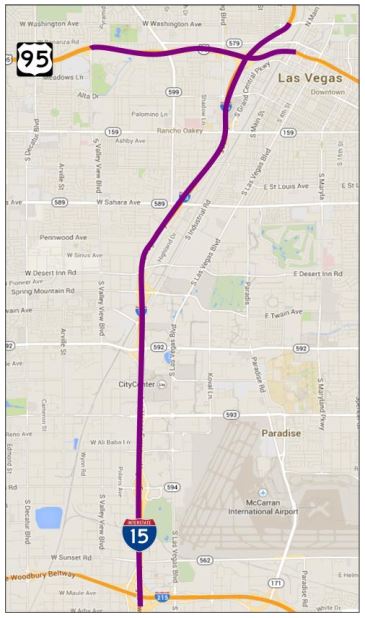
HOV lanes are dedicated lanes to be used exclusively by vehicles with two or more people–including buses, carpools, and vanpools. HOV lanes are in Las Vegas on U.S. 95 from Ann Road to the Spaghetti Bowl and on I-15 from the Spaghetti Bowl to Silverado Ranch Boulevard. HOV lanes can reduce travel time compared to general-purpose lanes and can move substantially more commuters than general-purpose lanes.

What Are the Benefits of HOV Lanes?

Screenshot describing HOV benefits, including better connectivity, improved air quality, system efficiency, saves money, less congestion, and saves time

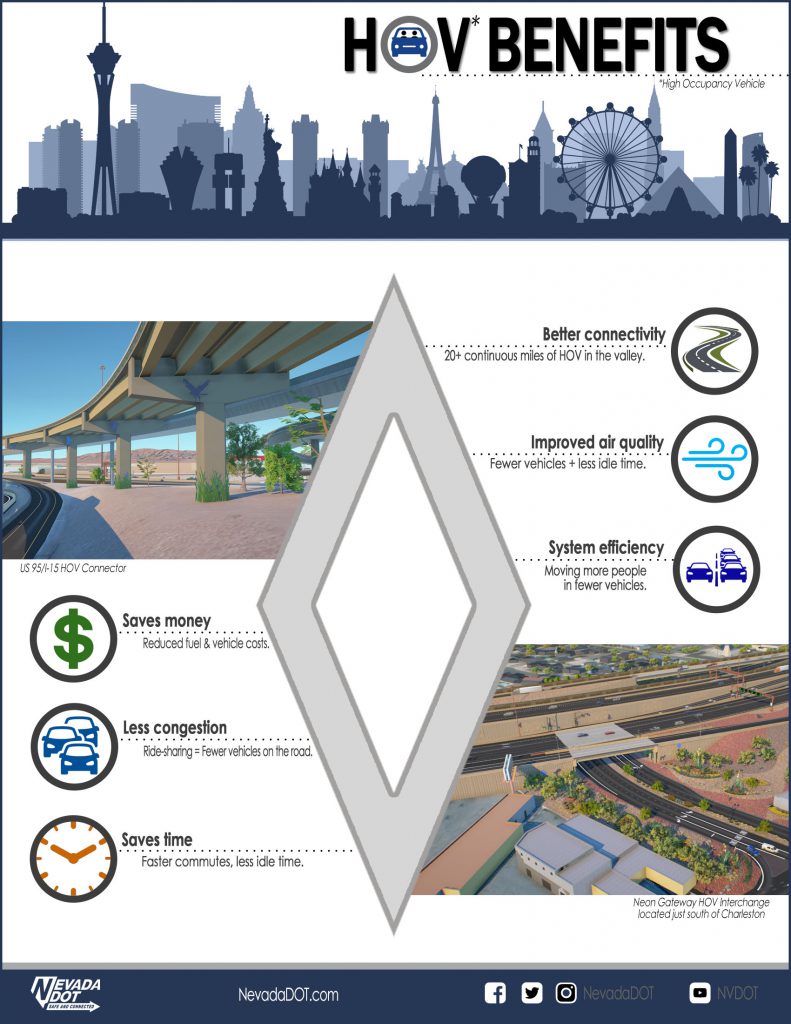
HOV lanes can reduce peak-period travel time compared to general-purpose lanes and can move substantially more commuters than general-purpose lanes. HOV lane users experience less congestion, arriving at their destinations more quickly than those who do not carpool. It also costs less to ride a bus or to share a ride than to drive alone every day. Other benefits include a more reliable commute and less stress. The community also benefits. HOV lanes provide a better use of infrastructure and can serve more people than general-purpose lanes.

HOV Plan

The Nevada Department of Transportation has updated the Southern Nevada High-Occupancy Vehicle (HOV) Plan. The purpose was to update the previous plan (completed in 2007) based on the current conditions in Southern Nevada, including recently completed projects and Project NEON, and use the most recent analysis tools. Implementation of HOV lanes, or carpool lanes, is one method of maintaining mobility in congested freeway corridors. The HOV plan update focused on the near-term HOV system in Southern Nevada, including Project NEON’s direct connector between I-15 and US 95 and the conversion of past I-15 express lanes to one HOV lane and one additional general-purpose lane. In addition, evaluations and recommendations for the long-term HOV system, direct access ramp locations, and operations of the HOV system were included. The HOV system was evaluated utilizing the Southern Nevada RTC’s 2035 Regional Travel Demand Model with the Mode Choice Element.

Visit NDOT’s HOV Lanes page to learn more about HOV Lanes in Nevada.

TSMO Workforce Development Plan

The NDOT TSMO Program Plan was developed and formally adopted in January 2020. Within the Program Plan, NDOT has identified several Programmatic action items to help implement TSMO in an integrated manner. One of the listed action items is the development of a TSMO Staffing and Workforce Development Plan. This plan is intended to assist NDOT in recruiting, training, and retaining staff who are dedicated to helping advance and implementing TSMO. As part of this plan, NDOT has established the required steps in ensuring internal and external collaboration with stakeholders including internal divisions, regional stakeholders, and universities.